Early-season snow is more than a mood it changes commutes, school schedules, travel plans, heating bills, even crop decisions. Below is a practical, research-based guide to the first snowfall timing for 2025–26 across the United States, why it varies so much by place, and how to plan around the inevitable surprises. Where possible, this forecast leans on the latest NOAA Climate Prediction Center (CPC) seasonal outlooks and current ENSO guidance for winter 2025-26, plus historic first-snow “normals” from National Weather Service (NWS) offices.
First Snowfall Forecast 2025–26 Quick Summary
Item |
Details |
|---|---|
Big picture for 2025–26 |
CPC’s latest long-lead outlooks (updated monthly) and ENSO guidance point to ENSO-neutral trending toward a brief, weak La Niña in fall/early winter with probabilities highest in Oct–Dec 2025, then tapering into winter. This can favor earlier cold shots and storm tracks across the northern tier, but impacts vary regionally. |
What CPC outlooks do (and don’t) say |
CPC issues temperature/precipitation probabilities; it does not predict exact snowfall totals or precise first-snow dates months in advance. Treat first-snow windows as ranges, not guarantees. |
Typical first-snow “normals” |
Historic first measurable snow (≥0.1″) dates range from late Sept–Oct in high Rockies to late Nov–Dec in lower elevations and the Mid-Atlantic; local ranges can be several months wide. |
Official resources |
NOAA CPC seasonal outlooks and local NWS climate pages (first-snow normals, advisories). (Climate Prediction Center) |
What’s Steering First Snow in 2025–26
ENSO backdrop
As of early October 2025, CPC notes ENSO-neutral conditions with a likely transition to weak La Niña in fall/early winter 2025–26, then decreasing odds deeper into winter. La Niña episodes tend to tilt storm tracks and cold anomalies toward the Pacific Northwest and northern tier, with comparatively warmer/drier odds in parts of the South—but each event is different and this year’s signal is weak. Expect regional variability and week-to-week swings.
Seasonal probabilities, not day-by-day snow
CPC’s long-lead maps give probabilities of above/near/below-normal temperature and precipitation for multi-month periods (e.g., Nov–Jan, Dec–Feb). They are not deterministic day-by-day snow forecasts, and CPC explicitly notes that seasonal snowfall totals and exact first-snow dates aren’t predictable months ahead. Use these tools to narrow windows, not to circle a specific date.

Why your town differs from your neighbor’s
Elevation, latitude, proximity to lakes/ocean, and local topography matter. For instance, first snow in the Cascades or northern Rockies is climatologically much earlier than in nearby lowlands. In the Northeast, first measurable snow might arrive in late Oct for far-northern Maine but late Dec for coastal Mid-Atlantic cities.
First Snow Windows by Region (Best-Estimate Ranges)
Below are broad windows for first measurable snow (≥0.1″) based on climate normals, elevation, and CPC/ENSO context. Local weather systems can shift these windows earlier or later by weeks.
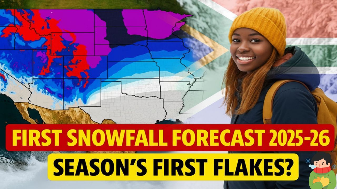
- Northern Rockies & High Plains (MT, WY, high-elevation CO):
Late September to early October at higher elevations; early to mid-October in adjacent high valleys/foothills. An early cold shot with upslope flow can bring a surprise even sooner up high. - Intermountain West & Wasatch/Uintas (UT, ID high country), Tetons:
Early to late October in the mountains; late October–November in populated valleys depending on elevation and cold intrusions. - Pacific Northwest (Cascades), Northern Sierra & Interior Northwest:
October for the Cascades and higher interior ranges; November for lower elevations and interior basins. Cooler/active Pacific patterns could nudge earlier mountain snows. - Upper Midwest & Northern Plains (ND, SD, MN, WI, northern MI):
Early to mid-November on average in many cities, though first measurable snow can occur as early as Oct or as late as Dec/Jan. Lake-effect belts can see an early November start with the right cold flow. - Central Plains & Midwest (NE, IA, KS, MO, IL, IN, southern MI/OH):
Mid-November to early December for many locations; earlier if a strong early-season front taps Gulf moisture and lifts along a boundary. - Northeast & New England:
Far northern/interior New England: late October to early November;
Interior NY/PA and northern New England valleys: mid-November to early December;
I-95 corridor from Boston to D.C.: more often late November to late December, with large year-to-year swings. - Interior West Lowlands & Great Basin (NV/UT valleys, interior OR/WA lowlands):
Late October to November in colder basins; coastal lowlands typically later. - Southern Rockies & Southwest High Country (AZ/NM/CO high terrain):
November in many ranges; December in lower elevations of the Four Corners region. - Mid-Atlantic & Appalachians (WV/VA/MD/PA high ridges):
Ridge tops can see early to mid-November; Piedmont/coastal areas usually late November to December, highly track-dependent. - Southeast & Gulf States:
Snow is rare; when it happens, it’s typically mid-winter (Jan–Feb) during strong cold spells and precise storm tracks. (Plan for cold rain; consider snow a bonus.)
Planning tip: CPC’s weeks-2 and weeks-3 outlooks narrow risk windows for cold/precipitation 1–3 weeks ahead. That’s the sweet spot for watching for your first snow risk.
Why First Snow Forecasts Change
Even with a La Niña/neutral backdrop, day-to-day weather is driven by short-wave troughs, jet streaks, and frontal timing. A single storm tracking 100–200 miles differently can turn snow into cold rain (or nothing). That is why NOAA stresses probabilities, not guarantees, at seasonal lead times. Use long-lead guidance to plan, then watch 7–10 day forecasts for actionable detail.

How to Use This Forecast (Without Over-committing)
- Travel: Build flex into late-Oct/Nov trips to mountain regions and the northern tier; consider refundable fares or changeable reservations.
- Schools & Events: Pencil in contingency plans around early-November in snow-prone interiors and highlands.
- Home & Fleet: Schedule winterization (furnaces, tires, plows) before your local historic first-snow median; supply chains tighten after the first big event.
- Farming & Landscaping: Use local NWS climate normals and the weeks-2/3 CPC outlooks to time final harvest and irrigation blowouts.
Frequently Asked Questions
Does NOAA predict my city’s exact first-snow date months ahead?
No. CPC publishes probabilities for temperature/precipitation over 3-month periods and does not issue seasonal snowfall totals or exact first-snow dates. Use historic first-snow normals plus the latest short-range forecasts.
Is La Niña a lock for early snow?
Not a lock ENSO this year is weak/short-lived in guidance. It tilts odds toward earlier northern-tier cold/storm tracks but local outcomes depend on shorter-term patterns.
Where can I find my town’s typical first-snow date?
Check your local NWS office climate page; many publish average first measurable snow tables and ranges.
Why do mountains get first snow so much earlier?
Elevation cools faster and wrings moisture from passing systems, shifting rain to snow weeks earlier than nearby lowlands. (The Cascades/Rockies often see September–October snow high up.)

Are the long-range maps useful for skiers/boarders?
Yes as context. They flag regions favored for colder/wetter conditions, but you still need weekly forecasts and storm tracking to time a powder day.
Conclusion
For winter 2025–26, expect first snow in the high West from late September to October, the northern tier largely by early to mid-November, and lower elevations/east-coast metros from late November into December with wide year-to-year swings. ENSO signals are modest and evolving, so keep an eye on CPC’s monthly updates and local NWS forecasts as autumn cold fronts sharpen. Plan in ranges, prepare early, and let the short-term forecasts decide when to break out the shovels.
For More Information Click HERE